Tsum and Manaslu Circuit Trek
Explore some of the Last Remaining Shangri-la around Tsum (the Valley of Happiness) and Manaslu.

Trip Highlights:

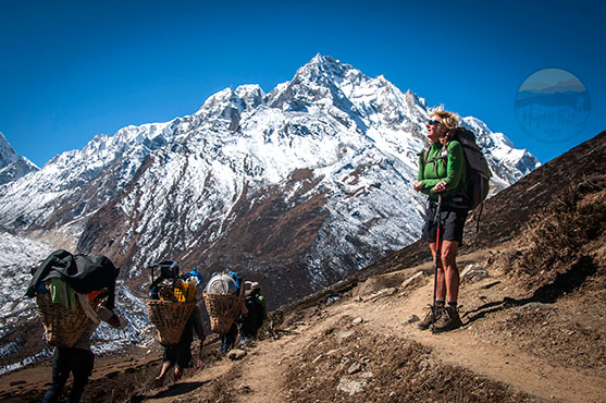
Join us on a journey into Tsum Valley, the valley of happiness, combining the Manaslu circuit trek. Tsum Valley is ahidden valley between Nepal and Tibet in the shade of Manaslu and Ganesh Himal. Explore ancient Buddhist culture, religion, and life. Trek to a least visited area away from a popular trekking route. Traverse enchanting woodland and barren high country with scenic landscapes. Marvel at the beautiful views of picturesque landscapes and the grand peaks of the Manaslu, Ganesh and Annapurna ranges. This is an adventure combined with a cultural trek to the far northern areas of Gorkha district and Mid-Western Himalaya. Enjoy the glamorous scenery from the start to the end of these beautiful walks. Explore the impressive cultural villages with Buddhists and Hindus. But what truly sets this trek apart is the variety of terrains you’ll experience, from low, warm areas to hills and an arctic zone of ice and glaciers. It’s a journey that will keep you on the edge of your seat, excited for what’s next.

Trek Profile

  • Mode of accommodation: Hotel with breakfast in Kathmandu and local Lodge on full board basis on the trek.
  • Mode of transportation: Comfortable tourist vehicles
  • Trekking Grade: Moderate to challenging.
  • Highest place: Larke La at 5,135m.
  • People and culture: Gurungs, Nupripas and Tsumbas (Tibetan origin) live in the Manaslu region, practise Buddhism and have an imposing culture. Magar, Gurung, Hindu Brahmins and Chettries inhabit the lower area.
  • Daily walk: 4 to 8 hours a day
  • Meal: Each individual has an open menu for each meal. For tented trek meals, each meal is prepared by our mobile cook and kitchen staff.
  • Trip duration: 26 Days (arrival to departure)

About Tsum and Manaslu Circuit Trek

Trekking around Manaslu and Tsum is amongst the great walks of the Himalayas with a bit of adventure. This three-week great walk offers incredible scenery of the Himalayas, including Ganesh Himal, Manaslu, and Annapurna.

The trip begins from Kathmandu with a Jeep drive to Jagat 1350m, from where the trekking starts walking through several villages to the secret valley of Tsum, hidden from the outside world of modernization, a Shangri-la, opened to trekkers only in 2008. The people of Tsum, the Tsumbas, are about 4000 in number, and much of their trade is with the Kyirong region of Tibet, which lies across two passes at the head of the Shyar Khola (east river) Valley. The fabulous views in the valley are of the Ganesh Himal, Sringi Hima, Baudha Himal and Himalchuli. Milarepa and Guru Rinpoche visited the Tsum, therefore considered a Beyul or hidden land. An important month-long pilgrimage route, the Kyimalung Circuit, runs through the Tsum Valley. This secret and sacred valley has several sacred sites, such as the Piren Phu (Pigeon Cave or the Milarepa’s Cave) near Burj village and several ancient monasteries such as Rachen Nunnery, Mu Monastery, Gumba Lungdang Nunnery and the villages of Chumling, Chhule, Chhekampar and Nile. The Tsum Valley trek ends by rejoining the Manaslu circuit trail at Lakuwa/Lokpa/Lokwa and continuing the Manaslu circuit.

The grand and lofty mountains of Manaslu, Bouddha Himal, Himal Chuli and Ganesh Himal Peaks dominate the Manaslu circuit trekking trail. The main villages of Manaslu, such as Lo, Sama Gaon, and Samdu, lie above the tree lines on the trail to Manaslu base camp, Larke La Pass 5,135m, and the Tibet border.

Mount Manaslu is called Kutang Kang in the local language and stands as the world’s 8th highest mountain, at an altitude of 8,163 metres, first conquered by a Japanese Expedition on May 9th 1956. Feared by the Khampa movement, the Tibetan separatist, the higher area of Manaslu was closed to visitors. The Manaslu area is bordered by Tibet and easily crosses both sides and is an old Trans Himalayan Salt and Caravan Trail of Nepal/Tibet.

The Larke La, at 5,135 metres, is the main pass that separates the Manaslu and Manang Marshyangdi Valley. After the Larke La, a long descent takes you back into the lush forests of rhododendron, oaks, pines and fir, and you reach the road head at Dharapani, where the Manaslu trail and Annapurna circuit trail meets or separate! After spending a night at Dharapani, extending the Annapurna circuit trek, Besisahar, or taking a direct drive to Kathmandu is possible.

If you extend the trek to Besisahar, the scenery of the lower valley, through the gorges of Marshayngdi River Valley, will treat you to a visual feast. Accordingly, the cultural life and different ethnic groups living together in harmony will inspire you to keep going to see what lies beyond the next bend.

Arrive in Kathmandu, customs and immigration formalities and claim your baggage, which takes some time. Upon exiting, the arrivals get a traditional welcome from the Happy Feet Nepal representative and transfer to the hotel. Reach the hotel and the rest of the day is free with the possibility of optional excursions (not included), but you can ask to organize any of the tours or stroll through its vibrant streets.

Kathmandu, the capital and heart of the country, with three medieval cities, symbolizes Nepal’s everything. Having lived through the several ruling dynasties of Buddhists and Hindus, the culture and society of Kathmandu Valley have evolved through time to give it more than a unique feature. Today it is an urban city, and still rapidly increasing, that has its ancient myths and, at the same time, is testimony to the greatness of people who have lived there for time immemorial.

  • Accommodation in Hotel Shanker, a 4-star hotel.

Free day in Kathmandu in preparation for the trek, or take a guided tour of around Kathmandu at places of interest, as Kathmandu city and the valley are filled with world Heritage Sites.

  • Accommodation in Hotel Shanker, a 4-star hotel, breakfast included.

An 8-hour drive.

Breakfast at the hotel in Kathmandu and start the early morning overland journey to reach Arughat town, the main trekking starting point. Since the road has climbed into the valley further north, we continue the drive to Jagat, where we stop overnight. It’s a beautiful countryside drive passing through many small towns, villages, jungles, rivers, waterfalls and stunning views of mountains and seeing the daily life of mid-hill Nepalese interwoven with different cultural and cast groups of people.

The name Jagat ‘tax’ village at 1410m is a village of Gurung people. We have to show our MCAP permits. In this zone, beans, potatoes, and maize are planted simultaneously – potatoes for food and suppressing weeds, and maize for food, providing a trellis for the beans, an essential protein and cash crop source.

A 5-hour trek

A new motorable track is underway until Sirdibas; therefore, we need to walk on the dirt road to Salleri at 1440m with sceneries of Sringi Himal at 7187m and then descend to Sirdibas at 1430m, where you will see your first signs of Buddhist culture here. Then, continue upstream on the left bank, up and down, before crossing Nepal’s longest suspension bridge to the east bank and a strenuous climb to the prosperous village of Philim 1595m, surrounded by rich fields of maize, potato and millet. The site is the headquarters of the Tsum-Nubri village Development Committee with a health post, a secondary-level school, a police post, Chholing Sandu Gonpa, and seven lodges with a large camping area. The area is inhabited mainly by the Gurung, Magar and Lama (Tsumbas and Nubripas).

After 1-hour of climbing higher and higher reach, Ekle Bhatti (Also called Chisopani), at 1600m, with eight good lodges, traverses over a spectacular ravine, an uninhabited area with ​pine trees and bamboo. Finally, descent to a trail junction with a new Teahouse for tea/lunch stop; left trail to Ghap and the right to Tsum Valley.

Hop on a well-graded, exposed track through pines and rhododendrons, looking down the path across the river. Climb up zig-zag steps, increasingly exposed, and catch your first views of the narrow lower Tsum Valley, steeply into the Shiar Khola that drains from the highest part of the valley. Across the Budi Gandaki River is Mount Himalchuli, 7893m above sheer cliffs. Trek through a largely untouched and peaceful temperate forest at Lowa 2240m., surrounded by barley fields, with two comfortable lodge accommodations. The main village is 10 minutes away from the lodge. The houses are classic Tibetan with wood barricades on the roof, but without flat roofs, as it rains and snows here. The village has magnificent views of the 7000m Ganesh Himal and Siringi.

A 4-hour trek.

The day starts traversing through rich agricultural land of corn and potatoes and crosses a big landslide of 2021 that swept away the suspension bridge just east of the Lokpa. Immediately we cross a stream over a bridge and a broad leaf-covered forest of new trees, including bamboo, rhododendron, and pine. We then cross a newly built long bridge on a sheer cliff above the Budi Gandaki River, which takes about 10 minutes to cross. Then the trail climbs a zig-zag trail through stone stairs and with occasional views of Siringi Himal. We then cross a suspension bridge above Shiar Khola, on the opposite bank and the perched village of Ripchet, 2468m above it. About 20 minutes of a zig-zag uphill walk and 10 minutes of level walking bring us to Chumling village, with two good lodge accommodations.

The main village of Chumling is 10 minutes above; therefore, after checking into the lodge and refreshments, we take a short walk to visit the Chumling village. The traditional village of Chumling contains ancient Chortens, mani-walls, several monasteries, a health post and a school, an electricity powerhouse, and has access to mobile and internet. The views from here are Ganesh Himal Range, Cherku Himal and Siringi.

A 5-hour trek.

The morning starts with a beautiful level walking through the farmlands of Chumling and other side villages for an hour and crossing the Dumje village at 2460m., a small settlement with a monastery. Continuing a further 30-minute walk comes to Renjam 2400m, an enclosed courtyard lodge with comfortable accommodations. Renjam is the trail junction to Tsum and Ganesh Himal Base camp. Cross a bridge above Serpu Khola at Renjam and, in forty minutes, reach Gho village, about 14 houses with a monastery and a newly built lodge. From Gho, we cross a loose landslide area and a well-graded but exposed road to Upper Tsum and the large village of Chhokangparo 3010m, stone houses nestled under the cliffs without an iron roof. The village’s original name is Chhokhangpar, the biggest village in the entire Tsum Valley.

The valley opens up here into extensive barley fields, corn, wheat, buckwheat and potatoes. See around and may encounter herds of tahr with gracious mane, often graze the wild cliffs to the north. Cross the fields and reach Chhokangparo with seven comfortable lodges accommodations. In this area, you can enjoy salt tea with fresh Nak butter and milk, Tsampa, Tibetan bread and t-momos. Weather permitting, you can see the valley and Himalchuli 7893m.

A 4-hour trek.

The friendly people of the Tsum region speak Tsumba, related to Tibet but often little to Nepal and are widely used by visitors. Continue east, passing small villages and past a local school, climb over a ridge with a  Chortens and past Lamagaon village 3202m (the second biggest village of Tsum valley) through flat fields, looking out across the arable fields and a huge courtyard from the Rachen Gompa 3240m. This nunnery is the equivalent of the main monastery in Kathmandu, in Kopan, near Boudhanath Stupa. There is another big monastery, a monastic school, called Tsum Monastery, and you can visit it on the way.

After a visit and tea/lunch break, we reach Burji village, about 20 houses. From Burji, go up for 20 minutes and visit the cave of Milarepa or the Piren Phuk, the sacred site where the Buddhist saint Milarepa meditated for 26 years. It is believed that the site was visited by the Guru Rinpoche, the founder of Tantric Buddhism in Tibet, before the Mila Repa, and he meditated here. Then, cross the Shiar Khola and pass-through villages via Phurte 3251m, Pangdun 3258m, and pass a stupa to reach the larger village of Chule 3347m through an impressive gate (Kani) entrance.

The children here all wear Tibetan robes called Chhubas, and there are many yaks. Cross the bridge and go up to Nile 3361m. Both villages are traditional, including cattle compounds and sheltered balconies for dry crops.

A 6-hour trek

Today we start early, moving up the valley on the west bank, enjoying the sunrise over the narrowing valley walls; yaks usually are kept there to graze. The final climb up to the Mu Gompa 3700m is through drier Tibetan country, with rows of Chortens and expansive mountain views. It is a large monastery with over 100 monks and an ancient gonpa. Further, 30 minutes west of Mu Gompa, there is an ancient meditation centre for nuns, and those interested can pay a visit. Depending on how you gain time, you can also visit Dhephyudoma Gompa 4000m to the west on an obvious track (2 hours more).

On three sides are clear views of the border with Tibet, with frequently used passes to the east (Ngula Dhojyang or Mailatasachin La, 5093m) and west (Thapla Bhanjyang 5104m) just out of sight. Some groups climb Kalung 3820 and spend a night hiking the passes to view Tibet, but you need a tented camp. There are extensive yak pastures in all directions, the Lungdang Glacier to the east, and high peaks in all directions.

Return down the valley through Chule and continue down to Phurre, but stay on the east bank of the Shiar Khola and traverse rocky plains to Rajen Gompa 3240m, where it is possible to visit the ancient gonpa with camping facilities. The oldest part of the nunnery is interesting. Each Tsum family usually has one family member as either a monk or nun in the monastic system. Continue south until the bridge crosses to the west bank, then descend to Chhokhangpar for an overnight stop.

A 6-hour trek

We start the trail below Chhokhangpar for around 2 hours until we reach a small gonpa at Gho 2485m. Descend on a narrow path to the left through the village and cross the bridge, over Shiar Khola, to Dhumje 2440m, with a Tibetan herbal medicine clinic and school. The path climbs forward just behind the clinic. Very steep climb on an indistinct track through pines and rhododendrons until the trail begins the trek at a wall of prayer flags.

Finally, take an uphill trail in the pine forest and climb through colossal silver pine trees to reach Gumba Lungdang, 3200m, perched on a hill with tiny beautiful nun houses with rhododendron forests above. This small gonpa with 40-50 nuns has an intense and absorbing puja from 6:00-7:30 every night. No formal lodge or camping area exists, but you can camp in the gonpa yard and use its kitchen with permission. Or there is a newly built monastery with basic accommodation without a restaurant, but one can eat whatever gets cooked for nuns.

The panorama of the mountains in all directions is incredible, and it may be one of the highlights of your trekking in Nepal. Spend the night in a tented camp or the monastic accommodation.

A 6-hour trek.

Descend from Gumba Lungdang and cross the Laudang Khola at Dumje and stay on the southern bank of the Shiar Khola. There are no hostels or Bhatti in Dumje. Climb over some deep gorges and wobbly bridges and arrive at picturesque Ripchet 2470m. Take time to look around at this fertile valley with Chortens in the fields backed by pine forests. Descend the steep stairs to the Ghumlong Bhatti, 2130m on the river, with some good lodges. Then climb again through pristine temperature forest to Lowa 2240m.

A 5-hour trek.

We continue from Lokpa along an exposed path to the Nyak Phedi, where the trails to Ghap and Tsum branches. Turn right, cross the Budi Gandaki, and arrive at a tea house at Nyak Phedi, where we can rest with tea or lunch, taking a last look toward the Tsum Valley.

We enter a narrow gorge with loose tracks up and down. Then cross over to the east bank and back to the west bank over an overhanging suspension bridge. Next, we enter Nupri, ‘the mountains of the west, through the bamboo forests to Pewa and Deng village 1800m, inhabited by the Gurungs who practise Buddhism. Just past Deng, cross back to the east bank, climb to Rana 1980m and pass the road to Bhi 2130m—the river roars below except where a mountain landslide has created a massive dam.

The walk goes in and out of canyons, crosses the Serang Khola River from the north and climbs steeply again before finally circling at Ghap 2160m. The walls of Mani here and onwards to Bhimthang show intricately engraved carvings of various Buddhas in meditation, incised into the local hard stone by a family of Bhi carvers.

A 4-5 hour hike, moderately challenging with some steep uphill sections.

The trail starts uphill from Bihi village. It offers a lush forest with occasional ibex, Himalayan pika, Himalayan marmot, and Himalayan cockerel, as well as a beautiful landscape of hills and river valleys, waterfalls, and snow-capped mountains. On the way, you pass through Tsak and Kogpa, two small settlements with tea houses.

Serang Goma, at an altitude of 3100m, is a peaceful sanctuary at the base of Mount Sringi. The monastic village is built on a long meadow and has a nunnery. The monastery premises are graced by ancient trees, believed to have been planted by a visiting monk from Bhutan. The three summits of Mount Sringi are revered as Buddhist deities (Manjushree, Avalokeswori, and Vajrapani).

Start your day with breakfast at the monastic guest house. Engage yourself in the spiritual ambience as you witness the morning monastic sessions and the activities of the monastic school. Visit the head monk of the monastery, and if time and interest permit, follow the guidance of the ascetic monk. Hike and visit some sacred meditation caves, immersing oneself in the rich cultural heritage of this peaceful sanctuary. Watch for wildlife near the monastery; the non-harming Buddhist teaching allows them to roam freely, adding a touch of nature’s beauty to one’s spiritual ambience.

A 6-7 hour hike.

This day, after morning prayer, leave the monastery. Bid farewell to the nuns and monks and start the day. The trail meanders between rolling hills, rocks and high ridges, with incredible views of the mountain tops and deep valleys. The day is mostly downhill to Ghap village. Ghap is quite a large village. The mani walls here and onwards, to Bimtang, often display quality intricate carvings of various Buddhas in meditation, incised into the hard local stone by a family of Bhi carvers.

A 6-hour walk.

Continue in and out of canyons, cross the Serang Khola coming in from the north, and climb steeply again before finally turning at Ghap (2,160m; Tsak). The mani walls here and onwards to Bimtang often display intricate-quality carvings of various Buddhas in meditation, incised in the hard local stone by a family of Bhi carvers.

Enter a beautiful fir and rhododendron forest with lots of birdlife, stay on the south bank, cross north on a suspension bridge with a roaring narrow canyon below, then cross back to the south bank on a second bridge watching for grey langurs. The main trail now climbs up well-made stairs, but a shortcut to the right just after the bridge and along the river bank is much quicker and passes through a magnificent pine forest. Reach the tidy village of Namrung (2,660m) after about 1.5 hours from Ghap, with shops, a restaurant and a lodge across the crowded square. Stay overnight at the Lodge.

A 4-hour walk.

The trek starts passing fields and houses and enters rhododendron, spruce, and oak forest before climbing to Lihi 2900m in 45 minutes, with stupas and farm fields within Yak herder huts and shelters and a close-up view of Ganesh Himal and Himal Chuli. Next, the trail descends to a side valley of Simnang Himal with a close-up view of Ganesh Himal. We then cross the Sho with an extraordinary view of the Manaslu, Manaslu North, Naike and Lho villages. Lho is a big village with about 80 households, two monasteries, stupas, mani-walls and a school. At Lho Gaon, enjoy close views of the towering north face of Manaslu and visit the Ribung Monastery, a famous monastery in the region with numerous Chorten, Mani and with about 100 monks. Exit the Lho village following the river on the right bank with a view of Peak-29. After about two hours of climbing through the forest, the trail takes us to the village of Shyala. Shyala is beautiful with views of Peak 29 or Ngadi Chuli, Himal Chuli, Phungi, Manaslu and its massive glacier straight ahead, and now Ganesh Himal is far at the end as we are heading northwest. Shyala is a village with about 60 households and several good lodges. The village is prosperous with a monastery, several ancient mani-wall and Chortens.

A 5-hour trek.

Today, take an excursion to Pungyen Gonpa, situated at 4,050m at the end of the Pungyen Valley. This side excursion offers some of the most stunning views of Mount Manaslu, weather permitting. During the excursion, you can see the majestic sight of grazing yaks and giant vultures soaring overhead.

Pungyen Gonpa is located at the end of the valley on the mountainside with carved stone huts. It is one of the oldest Tibetan monasteries in the Manaslu region. It was built by some early Tibetan settlers, known as the Nubripa (Nubri people). The monastery’s name is “Pungyen,” the old name given to Manaslu by the Nubri people. The other local name for Manaslu is Kutang.

After his beautiful excursion, we make the 45-minute return journey. Enjoy lunch at Syala and a 2 hours walk takes us to Sama Gaon town with magnificent views of Mount Manaslu. Sama Gaon is one of the largest villages in this region. The inhabitants are mostly farmers who grow what they can in this rough terrain and cold climate, but the main ones are buckwheat, wheat, barley, potatoes, and some vegetables. The locals reach the border with Tibet in one day. It is one of the ancient salt trade routes between Nepal and Tibet. People around the upper Manaslu valley are descendants of the southwest of Tibet, way back more than 2000 years. The custom and culture are no less similar to Tibetan predecessors.

From here, it is only half an hour to reach our camp at Sama Gompa (only if we are taking a camping trek), just above the village of Samagaon. Set up our camp next to the monastery and visit the Sama Gompa, one of the region’s main Nyingma (red hat sect) Monasteries.

Rest day for acclimatization and local excursion. Sleep and relax and take a late breakfast or as you wish; an early wake-up benefits sunrise colours on the summit of Manaslu and around. Or consult with your guide and take an optional excursion to Manaslu Base Camp (4,800m.) with a packed lunch, about 6 hours. Or a side excursion to Birendra Lake

A 4-hour trek.

From Sama Gaon, the trail again descends to meet Budi Gandaki and follows it to a bridge to cross the site stream. Passing several mani-walls with thousands of Buddhist mantra carved stones, come over through Himalayan Juniper and birch forest to Kermo Kharka (Nay/Yak shed), where the trail descends to Budi Gandaki and crosses a wooden bridge with a steep climb to Samdo. The day’s trek is a pleasant walk of four hours to reach Samdo, the last village of Manaslu Valley. The elevation, mountain atmosphere, and dry air make the walk slower than earlier in the lower valleys. Though the surrounding is beautiful, every direction is filled with mountains and valleys, making every rest time a photographic moment.

We can see the main road to Tibet through the Lajyang La 5098m slope to the valley on the right. The road to Larke La is ahead on the left. The road from Tibet is closed, but timber stocks are being carried to Samdo by pending yak resumption of trade. The nearest Tibetan town is only a day away, and you can have Chinese and Tibetan beer and food at Samdo.

A 4-hour walk.

Today, we leave the last village of upper Manaslu Valley, descend to meet the Budi Gandaki River, cross the wooden bridge, and gradually climb to the Larke Phedi. Finally, the walk leads to the end of the valley facing incredible views of the snow-capped peaks of Manaslu; for locals, Manaslu is Kutang Kang.

The walk continues crossing two icy streams and reaching Larke Phedi, also known as Dharmasala (travellers’ rest house/shade). Larke Bazaar with a ruined town still known as Larke Bazar or an old fairground. In the past, the Tibetans, Nepalese and Sherpas from Namche Bazar (Everest Zone) came here for trade, giving this place a famous name. At Larke Phedi, the afternoon is free for short walks and rest. However, the next day requires an early morning start with a long climb to cross Larke La Pass and reach Bhimthang (Bemathang) in the Manang areas.

An 8-hour trek.

From Larke Phedi, an early morning walk leads through a steeper climb over the moraine of rocks and boulders, following north of Larke glacier, with grand views from Cho Danda with Larke Peak, clear glacier, beautiful valleys, glacial lakes and a range of Himalayan fauna and flora. Finally, a long but gradual ascent brings us to the top of Larke La, adorned with thousands of colourful Buddhist prayer flags! From the top of Larke La, there is an excellent panorama of Himlung, Cheo Himal, Kang Guru and Annapurna II, Larke Peak, and other peaks.

After Larke Pass, we descend over the moraine to the west, on the right-hand side of a deep ravine, then drop steeply down a scree road. Some sections of snow or ice make the walk treacherous. Then, finally, make a long descent over loose gravel to a more welcome level area with grassy moraine, where we feel more relieved.

The track now heads to the left of the large and sometimes rocky lateral moraine into a widening and beautiful valley to picturesque Bhimthang (original name is Bemathang) 3520m, a 1400m descent in about 3hrs. The views during the descent are enormous – icefalls and mountains in every direction, a glacial lake (Pongkar Tal) between the Pongkar and Salpudanda glaciers, and the joining of these two glaciers with a third glacier to form the Salpudanda Glacier, whose lateral moraine towers over Bhimthang (Bemathang). Bhimthang (Bemathang) means the meadow of sand, it is a lovely place lying on a vast green valley with several good lodges adorned with prayer flags and a view of the looming Manaslu. The area surrounded by Himalayan Juniper, tall green rhododendron, pines, and oaks is one of the famous rhododendron sanctuaries in Nepal.

A 5-hour walk.

Breakfast and stroll around to find views of your preference. A nearby ridge provides a grand view of Manaslu, Lamjung, Himlung and Cheo. From Bemathang, enjoy a much-relaxed downhill walk, cross the Yak pasture meadow, cross a bridge over the Dudh Khola, and enter a rhododendron forest to reach Karche, a high-altitude cultivated land. Cross the lush cultivated field and a steep climb over a ridge at a big sweeping arc at a riverbank. A short walk reaches a small clearing, amid wood, at Gho, a small cattle and yak herders’ summer pasture, where we make our overnight stop. Gho is a temporary settlement with four good lodge accommodations to serve trekkers.

A 3-hour walk and a 4-hour drive.

The last day of the trek! A pleasant walking downhill through a beautiful forest reaches Tilje village, a nice place beside the raging Marysangdi River. From Tilje, the last climb brings us to cross a suspension bridge over the Marshyangdi River and reach Dharapani. This village is located at the junction of the classic Annapurna Circuit Trail and Around the Manaslu Trekking route and is linked with Kathmandu by a motorable road.

The walking ends here, and we stop for lunch. After a marvellous adventure around Manaslu, we take about 4 hours driving to shorten the driving distance to Kathmandu and complete our holidays in the Himalayas with much pleasure. The road mostly follows the Marysangdi River and passes through Taal Besi, Chamje, Jagat, Ngadi, Bulbule, and Besisahar with terraced paddy fields. Besisahar is a large town and the headquarters of the Lamjung district.

A 6-hour drive.

Breakfast and drive to Kathmandu. The Dharapani to Besisahar is by Jeep drive, and Besisahar to Kathmandu is by car, Landcruiser or Hiace van or Bus, depending on the number of persons travelling together.

From Beshisahar, the drive leads past many farm villages and towns and joins the main highway of Kathmandu and Pokhara at Dumre. Then continue a busy road back to Kathmandu.

A reserve day to make sure of a trouble-free itinerary. If all goes well, use the extra day to visit some of the medieval towns of Kathmandu, such as Bhaktapur, Patan, Boudhanath Stupa and Swayambunath Stupa, some of not to miss sites in the Kathmandu valley when you are already here.

Breakfast and the rest of the day are leisure on your own. The Representative of Happy Feet Nepal will arrive at your hotel with transport three hours before your departure flight time. Get escorted from the hotel to the International Departure Terminal, see off formalities, and go through the immigration and departure.

Includes

  • Airport pick-up and departure service as per itinerary
  • Four nights hotel accommodation in Kathmandu, breakfast included (category 4-star hotel)
  • Happy Feet Nepal Trekking Kit Bag
  • One guide in the group and one porter, between every two members, for the entire trekking and one guide helper for every 6 members.
  • Insurance and all expenses of local staff
  • A satellite phone for communication in an emergency
  • An emergency medical kit box for first aid medical purposes.
  • Kathmandu to SotiKhola transportation by 4×4
  • Manaslu and Annapurna Conservation Area entry permit
  • Tsum and Manaslu Special permit
  • The trekking period, Kathmandu to Kathmandu on a full board basis and accommodations in teahouse lodges
  • Road transportation, Dharapani to Besisahar in Jeep and Besisahar to Kathmandu in a private tourist vehicle.
  • Agency service charge

NOTE: The following staff and equipment get included for the tented trek.

  • Trekking staff: one guide, two Sherpas (guide helpers), one cook, two to five kitchen boys depending on the number of persons in the group, porters and their expenses and insurance
  • All camping materials, such as a two-person dome tent, dining tent, kitchen tent, toilet tent, shower tent, dining table and chair, required kitchen equipment and all meals.

Excludes

  • Travel insurance (helicopter evacuation & emergency hospital treatment) is obligatory.
  • Travel insurance (trip cancellation/interruption eventualities) is not obligatory but at the client’s risk.
  • Nepal entry visa and visa fee (One can apply on arrival at Kathmandu airport)
  • Lunch and dinner in Kathmandu
  • Personal expenses
  • Alcoholic and mineral beverages during the trek
  • Other charges such as usage of the internet, telephone, and laundry services.
  • Tips for Nepali staff/porters and those not mentioned in the above price include section.

The Spring and the fall are always the best time to trek to the Manaslu region. However, the fall/autumn season, from September to November, is undoubtedly the best time to visit Nepal. The weather remains crystal clear, with breathtaking views of the Himalayas and the landscapes. However, it is colder at high altitudes during both seasons.

Theoretically, spring is the second-best, but spring is the first-best season for many. Spring is more interesting as the rhododendron and wildflowers blossom in the mid-hill region of Nepal, and the Bhimthang area is one of the rhododendron sanctuaries.

The summer, monsoon time for Nepal, is also a beautiful time to visit the high dry land such as Manaslu. The build-up of monsoons and clouds with rain feed the highland and turn the meadows into lush green valleys and hills. In summer, the high plateau gets carpeted with yellow and multi-coloured flowers and beautiful streams, and medicinal plants feed the Yak and Sheep grazing in the region. Summer is also the time of the year when the villagers who migrated temporarily to lower land or travelled to other destinations for work and business return home for agriculture and animal husbandry.

The winter temperature in the Upper Manaslu region may drop to -17 degrees from sunset to sunrise. The daytime temperature remains 0 to 18 degrees. The local people of all villages live there year-round. December to February is the business time for the people of the upper valley. They come with their hand-knitted sheep wool sweaters, bag, cap and belts and travel to Kathmandu and even India for business.
Let us know your Experiences

Subscribe
Notify of
guest
0 Comments
Oldest
Newest Most Voted
Inline Feedbacks
View all comments

Trip Overview

Destination Manaslu Region
Duration 26 Days
Starts from Kathmandu
Ending Point Kathmandu
Trip Style Trekking
Difficulty Moderate to challenging
Best Time Autumn and Spring
Transportation Comfortable Tourist vehicles
Accommodation Teahouse Lodge or tented camp
Max Altitude 5,135 m
Meal BB in City & full board on trek
Group Size 2 - 12 Pax

Inquiry Form

Customize This Trip